Tag Archives: hike

Autumn hike from Mutzig to Molsheim

A touch of summer in November while hiking in the woods and vineyards.
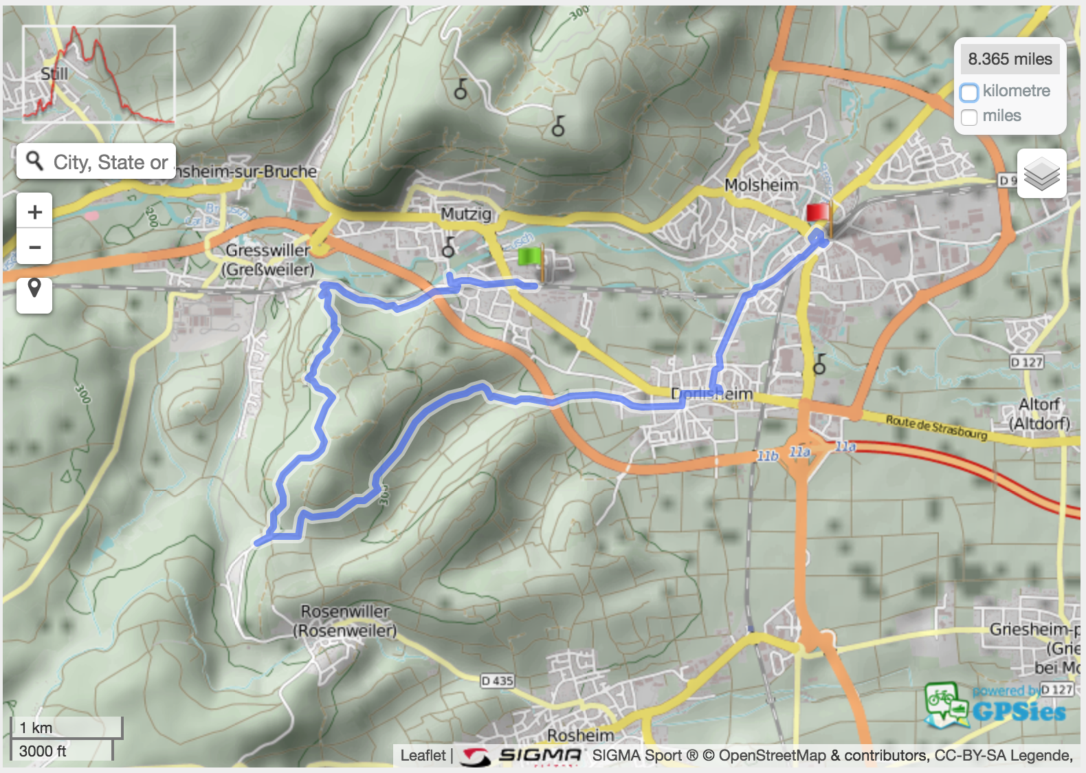
Start: Mutzig train station
End: Molsheim train station
Length: 13.5 km
Track: GPX file or GPSies link.
Photos: photo gallery and photo map.

Hangman
Hangman – it was the week of Halloween. Noticed a lawyer’s name on the letter box next to this.
House
House – an old but still inhabited house in Mutzig
Chapelle Notre-Dame des Sept Douleurs (Heilighiesel)
Chapelle Notre-Dame des Sept Douleurs (Heilighiesel) – unfortunately not a peaceful place as it lies next to a busy road.
(not so wild) life
(not so wild) life – at the second we stepped into their field, they came to us to see what’s going on.
Eating leaves
Goat eating fallen leaves like I would eat a bowl of peanuts.
Direction signs
Direction signs – at this stage we left the yellow circle to follow the red symbols.
Steps
Here we starting climbing. It’s a steep but very short climb.
Rocher du Geissfels
Rocher du Geissfels – where this narrow trail took us to
Vegetal revenge
The tree revenge – metal blended by the growing tree
Leaf
Many leaves from various trees
Forest
Changing direction but staying on the marked trail
Forest track
The forest path became a track
Tracks
Where the tracks meet
Misleading directions
This sign is to be rotated 90 degrees counter-clockwise
Panorama
Panorama
Not-so-green salad
Lunch break: a not-so-green salad
The outlook
The outlook
bench
Our picnic bench
Leaving the pass
Leaving the pass
Autumn colours
Autumn colours – back to the forest
Litter
Littering is one thing I do not understand.
Vineyard
Autumn vineyard – all shades of yellow, orange and red
Warm November
Yes, it’s November…
Grapes
Grapes
Grapes
Some old grapes; vendanges tardives?
Grapes
Grapes
Pinot noir
Pinot noir information board
More grapes
More grapes
Vineyards
Closed hut at risk of collapse in the vineyards.
Vineyard
Orange and red vineyard
Enjoying the weather
Enjoying the weather.
Another vineyard
Another vineyard
Plaine d'Alsace
View towards “Plaine d’Alsace” and the Black Forest
Horse
Horse one
Horse
Horse two
Vignoble de Dorlisheim
Old apples
Old apples
Old apple
Old apple
Old apple
Dried apple on an old apple tree
Church
Protestant church in Dorlisheim
Church
Around Dorlisheim church
Eurovelo 5
Cycling directions featuring Eurovelo 5 and Véloroute du Vignoble d’Alsace signs
Bee
Bees are still outside

Hike map:

Hike Dambach-la-Ville

Start/Finish: Dambach-la-Ville train station
Length: ~16 km
Itinerary:

Dambach-la-Ville hike

Photo gallery:

Memorial
Memorial
Fountain
Fountain
Can you find the stork?
EuroVelo 5
Véloroute du Vignoble d’Alsace (part of EuroVelo 5) goes via Dambach-la-Ville
Chapelle Saint-Sébastien
Ossuary
Ossuary: ce que vous êtes nous l’étions et ce que nous sommes vous le deviendrez.
View over Dambach-la-Ville
Bibelefelsen rocks
Bibelefelsen rocks
Château du Bernstein
Sign(ed) poem
Sign(ed) poem
Forest track
Forest track
Ortenberg Castle
Ortenberg Castle; do not confuse with Ortenberg Castle in Schwartzwald.
Scenery
Scenery
Hiking path
Hiking path
Tic tac toe wall
Tic tac toe wall
Coat of arms
Coat of arms

Circular hike Château de Hunebourg

Located between Neuviller-lès-Saverne and La Petite-Pierre, in Alsace, France, the hike may be started (and stopped) at Château de Hunebourg and a drink (and/or a meal) enjoyed.

As you may have seen (where the blue junk is), we lost track of the track at some point but it wasn’t hard to find it back. The walk is enjoyable and its distance is about 5.5 km. Download the GPX file.

Elevation map:
Elevation
Link to GPSies.

Hiking map

Here’s the map of the hike.

If you like, you can download the GPX file or view it on my sport tracker.
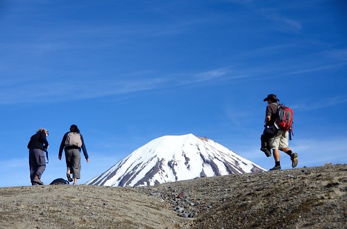