Mam Vëlo op d’Schaff, in short MVOS, is a yearly bike to work (or school) campaign run by the Verkéiersverbond (National Public Transport Community) from May 15 to July 31. They also encourage the participation of members on social networks; this year the hashtag was #mvos2018.
So I decided to make a Map, using the tools from VeloViewer, which does the job much better and faster than me.
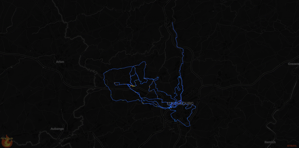
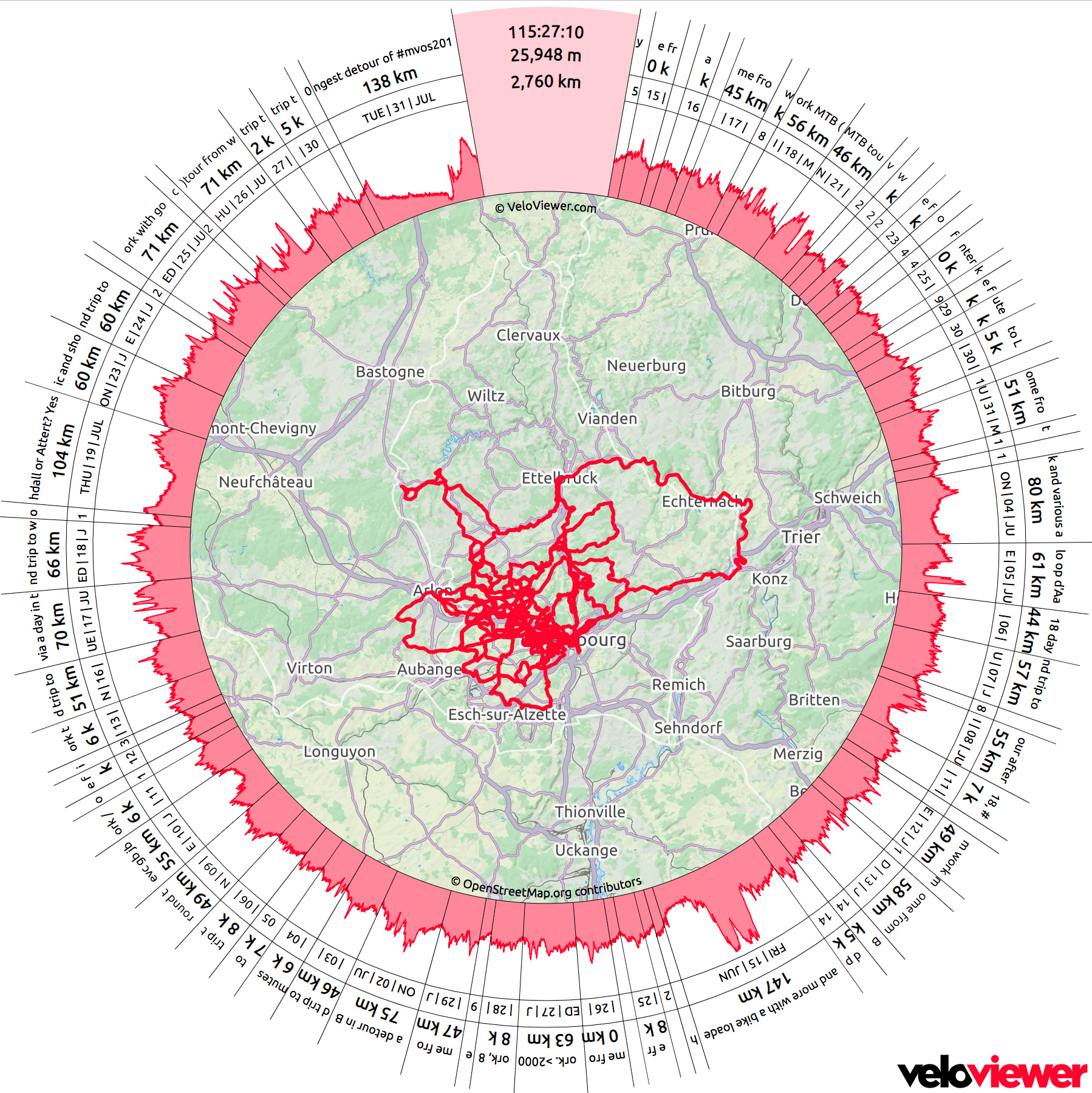
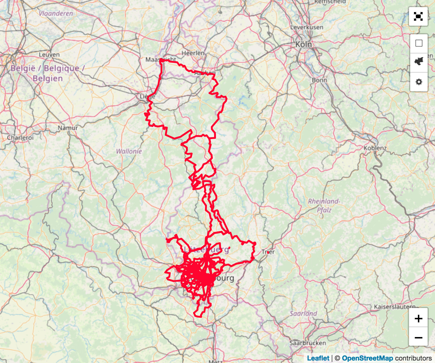
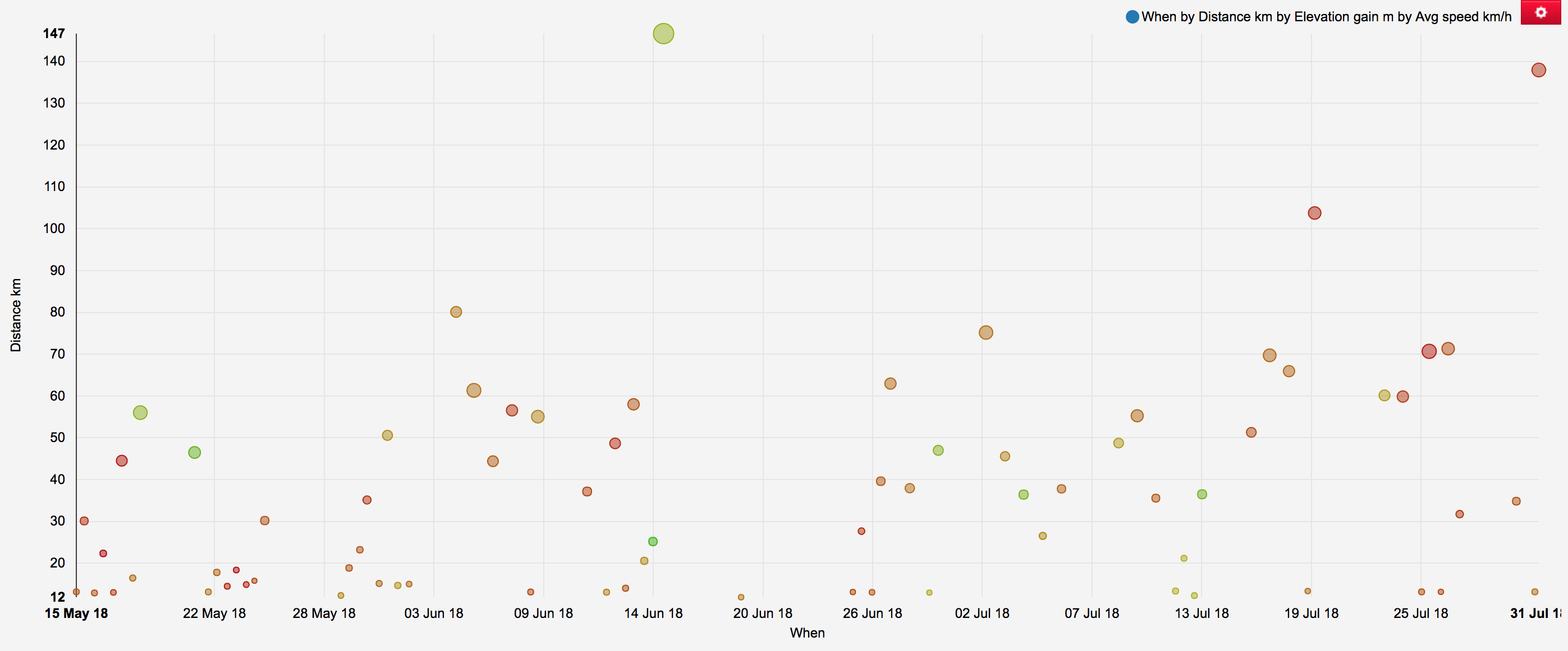
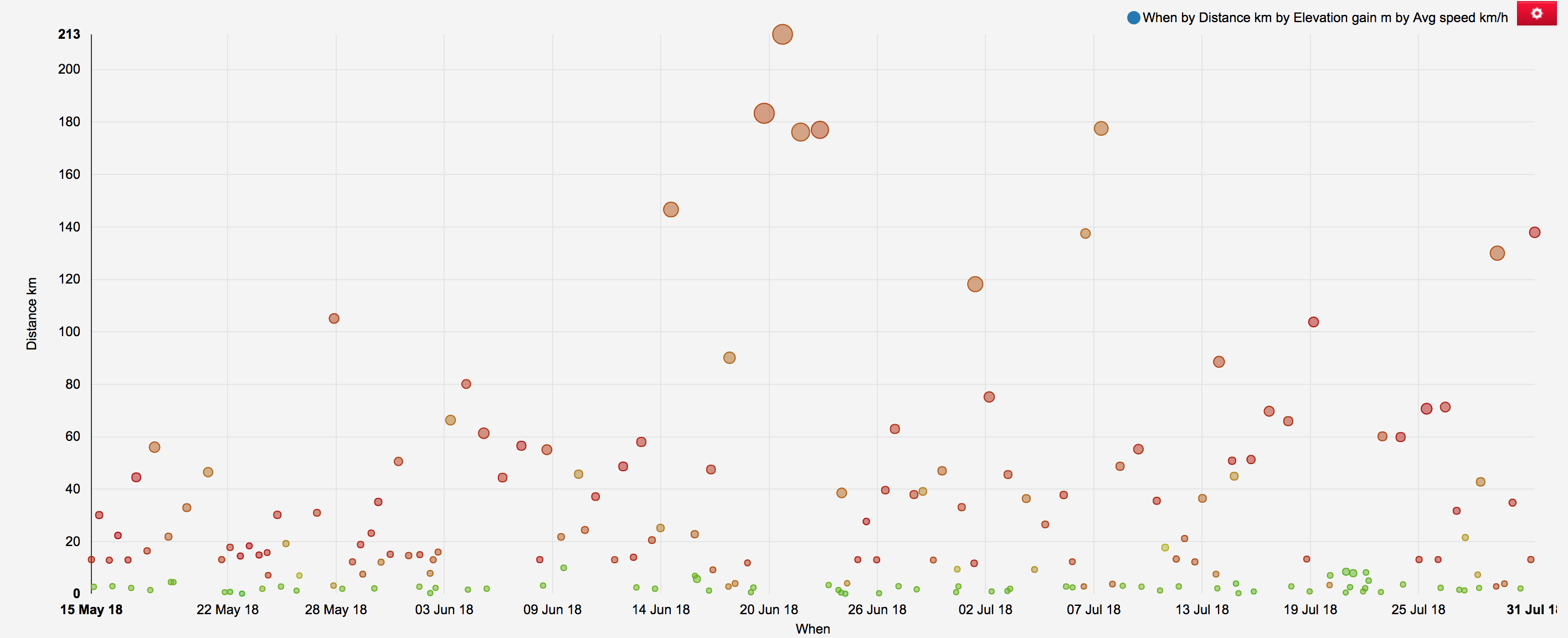
Bike to work map during #mvos2018 operationMap of all active transportation during #mvos2018 period.Summary of Bike to WorkSummary of all active transportation activities during #mvos2018 period (size of the point: elevation gain; colour of the point: average speed)
But I have shot several photos and published 225 of them on my Gallery! Below is a small sample of the landscape I shot either on my way to work, or most likely after work. With the long days I was able to do several (de)tours and explore roads and tracks I have never been before.
https://g.kewl.lu/picture/5986/tags/2774-mvos2018
Hopla geiss: a hook to Koerich Castle for the first day of MVOS2018 (day 82 of #mvos365 in 2018)
https://g.kewl.lu/picture/5989/tags/2774-mvos2018
I really love the #PC12Lux part in the forest between Eischen and Steinfort, will try Hovelange soon.
https://g.kewl.lu/picture/5996/tags/2774-mvos2018
A “short” (de)tour after work via the famous #Hobscheid tunnel on #pc12lux, following some forest exploration. I’d like to play some trumpet or didgeridoo in there
https://g.kewl.lu/picture/5995/tags/2774-mvos2018
To be at the right place at the right time, and an invisible scenery to motorists.
https://g.kewl.lu/picture/5998/tags/2774-mvos2018
Guess what happened next?
https://g.kewl.lu/picture/6827/tags/2774-mvos2018
Ready for a swim to work
https://g.kewl.lu/picture/6003/tags/2774-mvos2018
https://g.kewl.lu/picture/6000/tags/2774-mvos2018
Managed to avoid the thunderstorm of the day
https://g.kewl.lu/picture/6007/tags/2774-mvos2018
https://g.kewl.lu/picture/6804/tags/2774-mvos2018
#mvos2018, done. Today I was privileged not only to cycle to work but also to do a business trip by bike.
A touch of summer in November while hiking in the woods and vineyards.
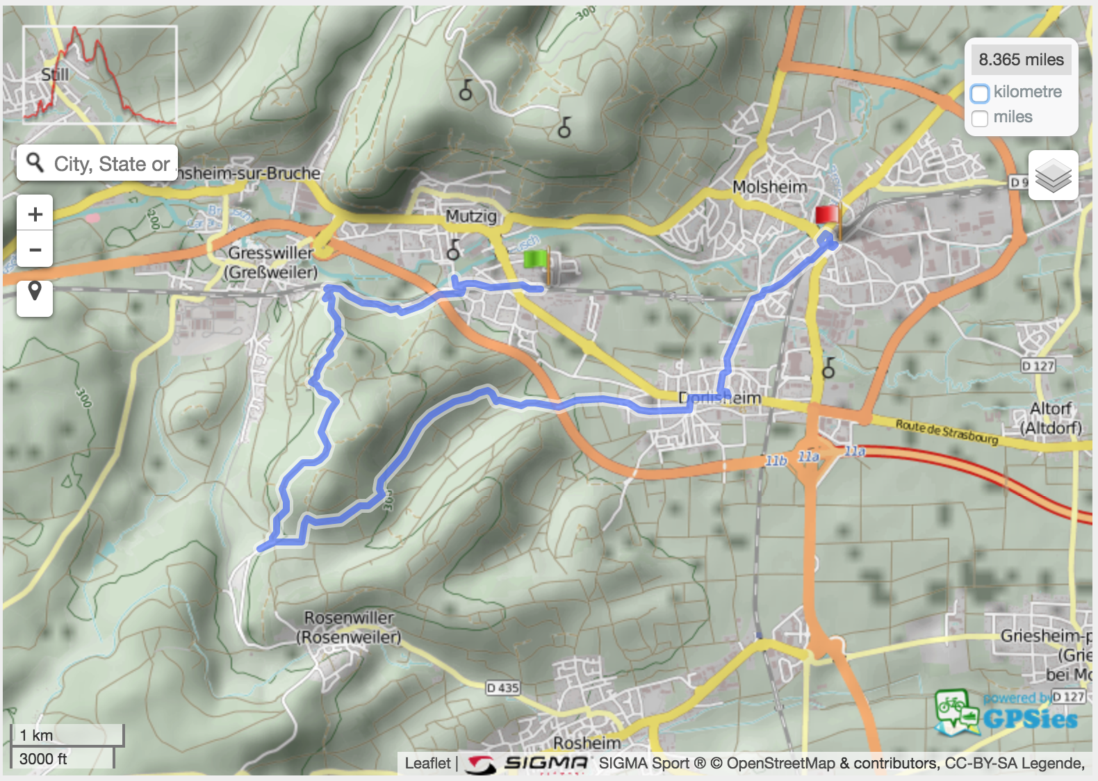
Start: Mutzig train station
End: Molsheim train station
Length: 13.5 km
Track: GPX file or GPSies link.
Photos: photo gallery and photo map.
Hangman – it was the week of Halloween. Noticed a lawyer’s name on the letter box next to this.
House – an old but still inhabited house in Mutzig
Chapelle Notre-Dame des Sept Douleurs (Heilighiesel) – unfortunately not a peaceful place as it lies next to a busy road.
(not so wild) life – at the second we stepped into their field, they came to us to see what’s going on.
Goat eating fallen leaves like I would eat a bowl of peanuts.
Direction signs – at this stage we left the yellow circle to follow the red symbols.
Here we starting climbing. It’s a steep but very short climb.
Rocher du Geissfels – where this narrow trail took us to
The tree revenge – metal blended by the growing tree
Many leaves from various trees
Changing direction but staying on the marked trail
The forest path became a track
Where the tracks meet
This sign is to be rotated 90 degrees counter-clockwise
Panorama
Lunch break: a not-so-green salad
The outlook
Our picnic bench
Leaving the pass
Autumn colours – back to the forest
Littering is one thing I do not understand.
Autumn vineyard – all shades of yellow, orange and red
Yes, it’s November…
Grapes
Some old grapes; vendanges tardives?
Grapes
Pinot noir information board
More grapes
Closed hut at risk of collapse in the vineyards.
Orange and red vineyard
Enjoying the weather.
Another vineyard
View towards “Plaine d’Alsace” and the Black Forest
Horse one
Horse two
Vignoble de Dorlisheim
Old apples
Old apple
Dried apple on an old apple tree
Protestant church in Dorlisheim
Around Dorlisheim church
Cycling directions featuring Eurovelo 5 and Véloroute du Vignoble d’Alsace signs


")
 life")